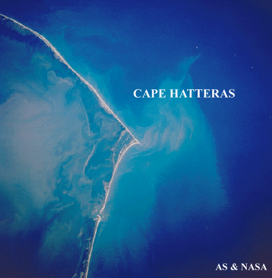
Cape Hatteras, NC (From Space)
Cape Hatteras marks the southern terminus of the striped bass migration.
About Cape Hatteras
Cape Hatteras is part of th Cape Hatteras National Seashore. Cape Hatteras was authorized as America's first national seashore in 1937, but was not actually established until 1953. The heart of North Carolina's Outer Banks, the cape offers some of the best beaches in the country. It is renowned for its surf fishing, and has some of the East Coast's best waves for surfing.
The Outer Banks
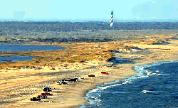
Cape Hatteras is a cape on the Outer Banks of North Carolina. It is the point that protrudes the farthest to the southeast along the northeast-to-southwest line of the Atlantic Coast of North America. That makes it a key point for navigation along the eastern seaboard. So many ships have been lost around it that the area is known as the "Graveyard of the Atlantic". The nearby shoals are known as Diamond Shoals.
The cape is actually a bend in Hatteras Island; one of the long thin barrier islands that make up the Outer Banks of North Carolina. Oceanographically, it is of interest because it is a point of confluence for two opposing currents: the warm Gulf Stream moving north, and a cold Virginian current moving south.
Surf Fishing on
The Outer Banks
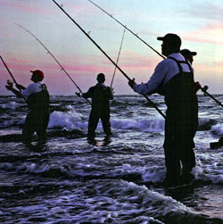
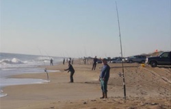
Surf Fishing at Cape Hatteras
Photo from National Geographic
Magazine, August 2006.
Many species that migrate, including the striped bass, have their southern terminus near Cape Hatteras. Striped bass winter in the deeper ocean waters off of the Outer Banks.
In the winter months,
surf fishermen
head for the beaches all along the Outer Banks hoping that some of these striped bass
will come close to shore. Sometimes they do, and great fishing results. The point at Cape Hatteras is a favorite
spot, but it can get crowded. See photos below.
The beach at the point is shallow sloping. Be prepared to cast far to reach the deeper water. Rods of 12 feet length or more, called Hatteras Heavers, are commonly used. When casting chunk bait you will need to use sinkers up to 8 ounces, and it is a good idea to use a shock leader. Bring lots of metals, like Kastmasters or Hopkins - big ones.
Fishing is usually also good along
the beach south of the point.
Another good spot is by the rip that forms at the point in Buxton, just north of Cape Hatteras.
The Outer Banks are also good places to catch sea trout and puppy drum.
Off Road Vehicles
The September 2012 issue of Audubon Magazine includes an interesting article about Off-Road Vehicle (ORV) beach access at the Cape Hatteras National Seashore.
The National Seashore extends for 67 miles from South Nags Head to Ocracoke Inlet.
Off-road vehicles long have been allowed on the National Seashore, however the Seashore hasn't had a formal off-road management plan in place. On February 2012, The National Park Service implemented a "final plan" for managing motorize access at Cape Hatteras. Under the plan, 28 of the Seashores's 67 miles are designated for year-round vehicle use, while 26 miles are set aside for pedestrian and wildlife. Except during peak tourist season, ORVs have access to the remaining 13 miles.
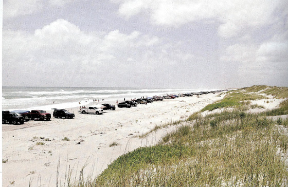
Off Road Vehicles at Cape Hatteras National Seashore South Beach.
Photo From Audubon Magazine.
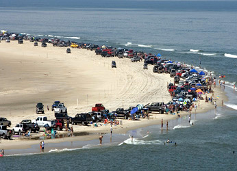
The Point at Cape Hatteras. The fish are biting, the fishermen have come.
Photo From The Southern Environmental Law Center.
Hurricane Damage
Cape Hatteras is also infamous for being constantly struck by hurricanes that move up the East Coast of the United States. The strike of Hurricane Isabel in 2003 was particularly devastating for the area. In fact, Hurricane Isabel ravaged the entire Outer Banks and also split the two small towns of Frisco and Hatteras in half. Route 12, which provides a direct route from Nags Head to Hatteras Island, was broken in half by the hurricane. This nearly demolished the small villages of Cape Hatteras. Students had to use a ferry to get to school for almost a year.
To see a Google Earth Photo of Cape Hatteras follow this Link: - Cape Hatteras
Book